OldMapsOnline & Georeferencer
68 results found
-
During mouse hover, add the date and the map's complete name.
I have five distinct year-by-year maps that I can use to see how Oakland, California has evolved. Its functionality is incredible!
Nevertheless, the names on the bookmarked maps list and the list of active maps are reduced foodle. This makes differentiating between maps difficult. Additionally, in order to determine which object corresponds to which year, you must click on it to see the map page, then scroll down to see the date.
If the year and complete title of the map you are currently hovering over could be displayed as a "tooltip" as you hover over things in the…
1 vote -
restore the overlay feature to its previous state.
In the past, selecting "overlay" from an old map would allow you to place it over a current map. It appears that this is no longer the case. It was a really helpful function, so I don't know why you removed it when i try geometry dash subzero.
1 vote -
Have you ever had this issue before?
I wish there was a mechanism to report problems like these to a curator so they could take the appropriate action. In happy wheels, a game where you race using physics and choose different characters, begin the challenging obstacle courses. Happy Wheels is a side-scrolling game with over a million players, where the objective is to navigate through challenging courses. You may play the entertaining game Happy Wheels on your phone or online. It keeps you content and joyful.
1 vote -
Gameplay Mechanics of Cookie Clicker 2
Explore the sweet world of cookie clicker 2 today, with just simple clicks, think carefully and upgrade to watch the growth of the empire you build.
Cookie Clicker 2 is a simple clicker game where the goal is to click on a big cookie to make as many smaller cookies as you can. To make cookie production easier, players can use these cookies to buy upgrades and unlock new features, like houses and special skills.1 vote -
Need your opinion
Have you tried presenter media? I am proposing a venture project to my investor, so for that I need to make a solid presentation. I have heard good things about it, as they have expert services. Furthermore, I have found a coupon code for this as well, which is Presenter Media voucher code. Share your review on it; I am waiting for your response.
https://www.reecoupons.com/view/presenter-media1 vote -
Do you have this problem before?
I wish there was a way to notify a curator about issues like these, and they could handle it accordingly. A brand new adventure awaits you with the return of geometry dash wave! Everything is brand new: levels, music, monsters, and more! Jump, glide, and soar your way through treacherous hallways and over sharp obstacles to see how good you are.
1 vote -
Problems in the AI system
AI systems can encounter various challenges, such as bias in data leading to biased outcomes, lack of interpretability in complex models, issues with scalability and performance, ethical concerns surrounding privacy and data security, and the need for continual adaptation basketball stars to new scenarios and environments. Addressing these problems requires robust solutions in algorithmic fairness, transparency, data governance, and responsible AI deployment practices.
1 vote -
Technology in Services
Technology in services encompasses the application of digital solutions and innovations to optimize customer experiences, streamline operations, and drive innovation within industries like healthcare, finance, hospitality, and beyond geometry dash. It plays a crucial role in transforming traditional service delivery models to meet modern expectations and challenges.
1 vote -
New coreball app
Prepare to be captivated by the exhilarating world of coreball game, an online sensation that will keep you hooked with its 1,200 levels of mind-bending challenges. This game presents players with a simple yet challenging objective: skillfully attach the ball to the central core without making contact with any of the other balls already connected to it. Mastering this task may seem deceptively straightforward, but it demands a clever approach, impeccable timing, and lightning-fast reflexes.
1 vote -
请在地图上删除1971年后以国家身份出现的台湾地区! Please remove Taiwan from the map where it appears as a country after 1971!
Oldmapsonline的工作者们,你们好!诚然,你们的平台为网友提供了一个不错的查询历史地图的渠道。但我想就台湾问题向诸位提出如下意见:台湾是中国的一部分,它不是一个国家,不应当以一个同其他国家同等的呈现方式存在于地图之上。
Greetings to the workers of Oldmapsonline! It is true that your platform provides a good channel for netizens to search for historical maps. However, I would like to make the following comment to you on the issue of Taiwan: Taiwan is a part of China, it is not a country and should not be presented on the map in the same way as other countries.虽然台湾地区曾遭受日本等国的抢占与侵略,但其为中国领土不可缺少的一部分仍然是国际社会的普遍事实。
Although the Taiwan region had been seized and invaded by Japan and other countries, it was still a universal fact in the international community that it was an indispensable part of China's territory.…1 vote -
How to rename title of map
Can I rename the title of map?
https://support.oldmapsonline.org/ geometry dash subzero1 vote -
I have some suggestions for you
Spending "Coaching Points" allows players to alter the rolls and influence the results of specific plays. In a genre where dice roll is prevalent, this introduces a new dimension of strategic gameplay.
Upon completion of the initial setup, which modifies a team's ratings across multiple offensive and defensive statistical categories, the play is decided by rolling dice and reviewing the corresponding basketball legends team chart.
1 vote -
View the entire map
Is there a way to view the legend or scale on the outer edge of the map?
1 vote -
Problems with phone version
Cannot download app or use online version. Says not compatible with my Samsung s24 ultra
1 vote -
Can I use map on here?
I was trying to georeference an azimuthal-projected map of the Arctic and its environs, but it wouldn't fit into the OSM/MapQuest cylindrical projection. Let's try out cluster rush for free
1 vote -
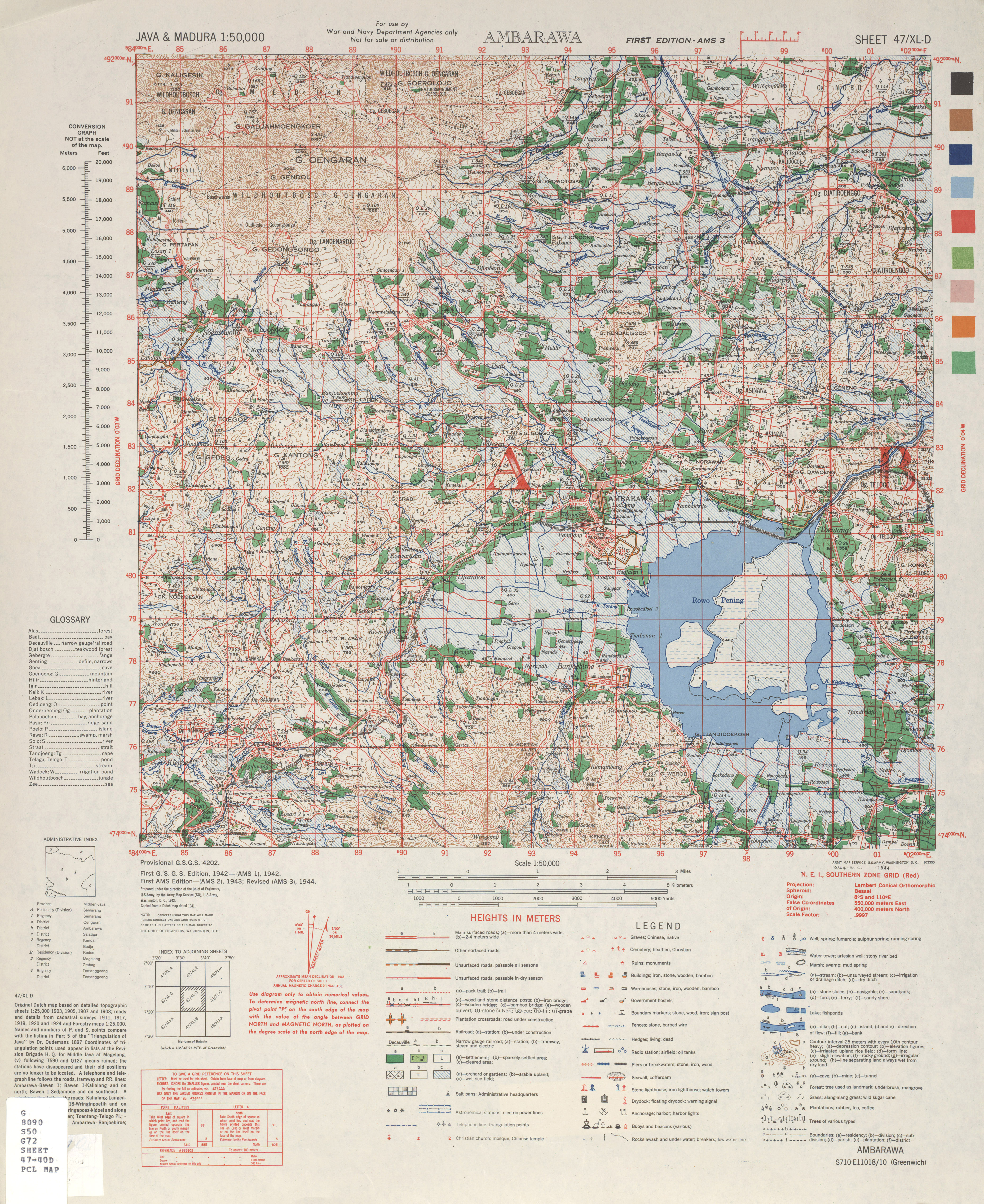
Use of militairy WW2 maps
Hi,
I found a great collection of WW2 militair maps that covers the world in very detailed maps.Some examples
https://maps.lib.utexas.edu/maps/asia.html
https://maps.lib.utexas.edu/maps/ams/java_and_madura/Here is a example of Ambawara, where civilian man and woman camps were placed during the Japanese occupation of Java
https://maps.lib.utexas.edu/maps/ams/java_and_madura/txu-pclmaps-oclc-6596455-ambarawa.jpg
These are detailed maps which you do not have on your website which covers most parts you do not cover yet.
1 vote -
Try a new entertain site for free
Mario is one of the most famous (and profitable) brands in the world. The franchise has been around for a long, but with the arrival of mario games in 2023, it looks like it's finally getting its mojo back. Not only does the film have the potential to redeem Nintendo's 1993 live-action film starring the brothers (which, in my opinion, wasn't terrible, but wasn't very good either), but it also has the potential to introduce the brothers' characters to an audience outside of the gaming world, who may be tempted to give Mario a try after all this time.
1 vote -
fix the overlay feature so that it works like it use to
It used to be that you could find an old map and choose "overlay" and it would overlay the map on a modern map. This seems not to be the case anymore. It was a very useful feature and I can't imagine why you discontinued it.
1 vote -
visit site : https://tlnconstructions.com/how-you-can-fit-a-small-fibreglass-pool/
Maximizing Your Space: Tips for Fitting a Small Fiberglass Pool in Your Backyard
1 vote -
Technical support question
Hello, a simple question: In Oldmapsonline the map-menu on the right hand side of the screen only shows a thumb-picture of the map and short name. How do I get to see the map's full information ?
1 vote
- Don't see your idea?